Fall Foliage Focus: Drives
Summit County is a wonderful place to spend your fall taking in the yellow, orange, and red hues that spread across the mountainsides. Being centrally located within the state, you are a short drive away from some of the most stunning views and brilliant fall colors Colorado has to offer. Listed below are some popular drives that will showcase the autumn hues you have been looking forward to.
Boreas Pass Road
Elevation: 11,482 ft
Distance from Breckenridge: none, starts in town
Directions: For the best views of the Ten Mile Range, take a drive up Boreas Pass Road. Take HWY 9 towards Blue River and turn left into Boreas Pass Road. Keep following this road. You will wind through some neighborhoods and end up on a dirt road that will take you to the top of the pass. If you keep going past the top of the pass, you will end up at the small town of Como. From there they you can take HWY 285 toward Fairplay and then take Hwy 9 back North to Breckenridge.
Scenic Stopping Points:
- Bakers Tank (on the left side of the road)
- Black Powder Pass (at the top of the pass)
Loveland Pass Loop
Elevation: 11,990 ft
Distance from Breckenridge: 57 minutes, 44 miles
Directions: From Breckenridge, head north on HWY 9, turn right onto Swan Mountain Road Turn right onto HWY 6 which will lead you past Keystone, past A-Basin, to the top of the Continental Divide. From the top, follow the road down Loveland Pass back to I-70. Head West to bring you back to Summit County and Breckenridge.
Scenic Stopping Points:
- Top of the Continental Divide
Independence Pass Loop (summer only)
Elevation: 12,095 ft
Distance to start of drive from Breckenridge: 26 minutes, 19 miles
Directions: Start at HWY 91 (next to Copper Mountain) and follow 91 through Leadville to HWY 82. Follow 82 to Aspen by going over Independence Pass. There are plenty of photo spots along the way, so plan on making a few stops to take in all the views. You can keep following HWY 82 until you reach the Glenwood Spring I-70 junction. Here you can take I-70 back to Breckenridge.
Scenic Stopping Points:
- Twin Lakes (past Leadville)
- Maroon Bells (past Aspen)
Guanella Pass
Elevation: 11,670 ft
Distance to start of drive from Breckenridge: 1 hour, 50 miles
This pass follows an old wagon route that lined the mining towns of Grant and Georgetown. It is the perfect detour on your way up to Breckenridge to start taking in all the stunning views of aspens turning. From Denver take HWY 285 towards Grant. Turn right onto Geneva Rd/Guanella Pass Road. Take this road 22 miles to Georgetown. From Georgetown take I-70 towards Breckenridge.
Scenic Stopping Points:
- Top of Guanella Pass
- Occasional ghost towns along the way


 https://bgvowners.com/wp-content/uploads/2022/10/680x400_GhostTour-scaled.jpg
1505
2560
Becca Clark
http://blog.breckenridgegrandvacations.com/wp-content/uploads/2024/01/bgv_logo.png
Becca Clark2024-09-25 09:30:022024-10-01 13:04:14Breckenridge’s Haunted History Tours
https://bgvowners.com/wp-content/uploads/2022/10/680x400_GhostTour-scaled.jpg
1505
2560
Becca Clark
http://blog.breckenridgegrandvacations.com/wp-content/uploads/2024/01/bgv_logo.png
Becca Clark2024-09-25 09:30:022024-10-01 13:04:14Breckenridge’s Haunted History Tours https://bgvowners.com/wp-content/uploads/2023/09/680x400_spooky.jpg
400
680
Becca Clark
http://blog.breckenridgegrandvacations.com/wp-content/uploads/2024/01/bgv_logo.png
Becca Clark2024-09-20 12:16:092024-09-20 15:06:08Seven Spooky Ways to Celebrate Halloween in Summit
https://bgvowners.com/wp-content/uploads/2023/09/680x400_spooky.jpg
400
680
Becca Clark
http://blog.breckenridgegrandvacations.com/wp-content/uploads/2024/01/bgv_logo.png
Becca Clark2024-09-20 12:16:092024-09-20 15:06:08Seven Spooky Ways to Celebrate Halloween in Summit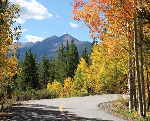 https://bgvowners.com/wp-content/uploads/2023/08/680x400_Fall.jpg
400
680
Becca Clark
http://blog.breckenridgegrandvacations.com/wp-content/uploads/2024/01/bgv_logo.png
Becca Clark2024-07-23 10:00:382024-07-23 10:23:50Leaf Peeping 101: Best Hikes, Bikes, and Drives
https://bgvowners.com/wp-content/uploads/2023/08/680x400_Fall.jpg
400
680
Becca Clark
http://blog.breckenridgegrandvacations.com/wp-content/uploads/2024/01/bgv_logo.png
Becca Clark2024-07-23 10:00:382024-07-23 10:23:50Leaf Peeping 101: Best Hikes, Bikes, and Drives
